Lépine
Lépine | ||
|---|---|---|
 |
| |
Region | Hauts-de-France | |
Département | Pas-de-Calais | |
Arrondissement | Montreuil | |
Kanton | Berck | |
Gemeindeverband | Deux Baies en Montreuillois | |
Koordinaten | 50° 23′ N, 1° 44′ O50.3869444444441.7347222222222 | |
Höhe | 3–59 m | |
| Fläche | 10,82 km2 | |
Einwohner | 266 (1. Januar 2016) | |
Bevölkerungsdichte | 25 Einw./km2 | |
Postleitzahl | 62170 | |
INSEE-Code | 62499 | |

Lépine ist eine französische Gemeinde mit 266 Einwohnern (Stand: 1. Januar 2016) im Département Pas-de-Calais in der Region Hauts-de-France (vor 2016: Nord-Pas-de-Calais). Sie gehört zum Arrondissement Montreuil und zum Kanton Berck (bis 2015: Kanton Montreuil). Die Einwohner werden Lépinois genannt.
Inhaltsverzeichnis
1 Geografie
2 Bevölkerungsentwicklung
3 Sehenswürdigkeiten
4 Weblinks
Geografie |
Lépine liegt nahe der Opalküste des Ärmelkanals. Umgeben wird Lépine von den Nachbargemeinden Wailly-Beaucamp im Norden, Roussent im Osten, Nempont-Saint-Firmin im Süden, Tigny-Noyelle im Südwesten, Conchil-le-Temple im Westen sowie Verton im Nordwesten.
Durch die Gemeinde führt die frühere Route nationale 1 (heutige D901).
Bevölkerungsentwicklung |
| Jahr | 1962 | 1968 | 1975 | 1982 | 1990 | 1999 | 2006 | 2013 |
| Einwohner | 367 | 319 | 268 | 279 | 296 | 297 | 283 | 271 |
| Quelle: Cassini und INSEE | ||||||||
Sehenswürdigkeiten |
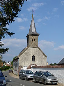
Kirche Nativité-Notre-Dame
- Kirche Nativité-Notre-Dame aus dem 15. Jahrhundert
- Schloss Le Puits-Bérault aus dem 19. Jahrhundert
Weblinks |
.mw-parser-output div.NavFrame{border:1px solid #A2A9B1;clear:both;font-size:95%;margin-top:1.5em;min-height:0;padding:2px;text-align:center}.mw-parser-output div.NavPic{float:left;padding:2px}.mw-parser-output div.NavHead{background-color:#EAECF0;font-weight:bold}.mw-parser-output div.NavFrame:after{clear:both;content:"";display:block}.mw-parser-output div.NavFrame+div.NavFrame,.mw-parser-output div.NavFrame+link+div.NavFrame{margin-top:-1px}.mw-parser-output .NavToggle{float:right;font-size:x-small}


