Liste der Einträge im National Register of Historic Places im Platte County (Missouri)

Lage des Platte County in Missouri
Die Liste der Einträge im National Register of Historic Places im Platte County in Missouri führt die Bauwerke und historischen Stätten im Platte County auf, die in das National Register of Historic Places aufgenommen wurden.[1][2]
Inhaltsverzeichnis
1 Legende
2 Aktuelle Einträge
3 Siehe auch
4 Einzelnachweise
Legende |
NRHP | Historic Place |
|---|---|
HD | Historic District |
Aktuelle Einträge |
[3] | Name[4] | Bild | Eintragsdatum | Lage | Ort | Beschreibung |
|---|---|---|---|---|---|---|
1 | Babcock Site | 497300001973 ID-Nr. 73001049 | Adresse nicht veröffentlicht | Waldron | ||
2 | Benjamin Banneker School |  | 499500001995 ID-Nr. 95001115 | 31 West 8th Street 39° 11′ 34″ N, 94° 41′ 6″ W39.192778-94.685 | Parkville | |
3 | Deister Archeological Site | 497000001970 ID-Nr. 70000347 | Adresse nicht veröffentlicht | Kansas City | ||
4 | Frederick Krause Mansion |  | 497800001978 ID-Nr. 78001672 | 3rd Drive Ecke Harrel Ferrel Drive 39° 22′ 9″ N, 94° 46′ 51″ W39.369167-94.780833 | Platte City | |
5 | Mackay Building |  | 497900001979 ID-Nr. 79001389 | Park College 39° 11′ 24″ N, 94° 40′ 48″ W39.19-94.68 | Parkville | |
6 | McCormick Distillery |  | 497400001974 ID-Nr. 74001090 | MO JJ 39° 23′ 54″ N, 94° 52′ 43″ W39.398333-94.878611 | Weston | |
7 | Missouri District Warehouse |  | 501000002010 ID-Nr. 10000476 | 357 Main Street 39° 22′ 15″ N, 94° 46′ 47″ W39.370833-94.779722 | Weston | |
8 | Platte County Courthouse |  | 497900001979 ID-Nr. 79001390 | 3rd Street Ecke Main Street 39° 22′ 15″ N, 94° 46′ 47″ W39.370833-94.779722 | Platte City | |
9 | Pleasant Ridge United Baptist Church |  | 500200002002 ID-Nr. 02000162 | MO P Ecke Woodruff Road 39° 25′ 53″ N, 94° 51′ 21″ W39.431389-94.855833 | Weston | |
10 | Renner Village Archeological Site | 496900001969 ID-Nr. 69000123 | Adresse nicht veröffentlicht | Riverside | ||
11 | Charles Smith Scott Memorial Observatory |  | 499200001992 ID-Nr. 92000625 | 8700 River Park Drive 39° 11′ 24″ N, 94° 40′ 45″ W39.19-94.679167 | Parkville | |
12 | Sugar Creek Site | 497300001973 ID-Nr. 73001050 | Adresse nicht veröffentlicht | Weston | ||
13 | TWA Administrative Offices Building | 500700002007 ID-Nr. 07001157 | 11500 Ambassador Drive 39° 18′ 7″ N, 94° 40′ 54″ W39.301944-94.681667 | Kansas City | ||
14 | Waddell "A" Truss Bridge | 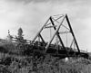 | 499100001991 ID-Nr. 90002173 | Brücke über den Rush Creek im English Landing Park 39° 11′ 9″ N, 94° 40′ 55″ W39.185833-94.681944 | Parkville | |
15 | Washington Chapel C.M.E. Church |  | 499200001992 ID-Nr. 92001055 | 1137 West Street 39° 11′ 42″ N, 94° 41′ 9″ W39.195-94.685833 | Parkville | |
16 | Weston Historic District |  | 497200001972 ID-Nr. 72000727 | Abgegrenzt durch Summit Street, Rock Street, Market Street und Ashley Street 39° 24′ 47″ N, 94° 54′ 6″ W39.413056-94.901667 | Weston |
Siehe auch |
- Liste der National Historic Landmarks in Missouri
- National Register of Historic Places in Missouri
Einzelnachweise |
↑ Auszug aus dem National Register of Historic Places – Platte County Abgerufen am 15. November 2012
↑ Department of National Resources – Platte County Abgerufen am 15. November 2012
↑ Die Nummerierung in dieser Listenspalte ist an der vom National Park Service vorgelegten Reihenfolge der Einträge orientiert; die Farben unterscheiden verschiedene Schutzgebietstypen des National Park Systems mit landesweiter Bedeutung (z. B. National Historic Landmarks) von den sonstigen Einträgen im National Register of Historic Places.
↑ National Register Information System. In: National Register of Historic Places. National Park Service. Abgerufen am 9. Juli 2010.
.mw-parser-output div.NavFrame{border:1px solid #A2A9B1;clear:both;font-size:95%;margin-top:1.5em;min-height:0;padding:2px;text-align:center}.mw-parser-output div.NavPic{float:left;padding:2px}.mw-parser-output div.NavHead{background-color:#EAECF0;font-weight:bold}.mw-parser-output div.NavFrame:after{clear:both;content:"";display:block}.mw-parser-output div.NavFrame+div.NavFrame,.mw-parser-output div.NavFrame+link+div.NavFrame{margin-top:-1px}.mw-parser-output .NavToggle{float:right;font-size:x-small}
National Register of Historic Places in Missouri Adair | |


